Essays
The Problem of Design and Navigation: A Case Study from Virtual Jamestown
Early in 1997 I first conceived the idea of Virtual Jamestown as a digital history archive on the World Wide Web. At first I thought I would place on a web site literally everything about Jamestown I could find—every text, every record, every artifact about Jamestown, its people, its meaning, its legacy. Given the paucity of records and archaeological evidence, this seemed within the realm of possibility, and it would create a "virtual" reconstruction of what we know or think we know about the Jamestown experience. I was especially interested in making visible the encounters and exchanges between Indians, Europeans, and Africans. Exactly how to present the archive proved far more difficult than I ever imagined. The problem of navigation and design became increasingly significant for the project, and we went through several redesigns and failed experiments in site navigation.
What seemed at the outset of the digital revolution a simple issue of Hypertext Markup Language (HTML) organization for a colonial history project turned into a complex set of considerations for presentation and navigation in the new digital medium. Gradually, it became apparent that the arrangement of technologies we call the "web" would require us to revisit some fundamental questions and revise some key decisions about the way we understand history and interpret history—indeed, we might ask how the technology has affected the act of being a historian. After a series of redesigns for Virtual Jamestown, I found that I was in different place from where I began. Instead of seeing the web as simply another means to represent colonial history, I was questioning whether the web would even allow us to create a true colonial or post-colonial history.
Why is design an important issue? As a naïve novice, I could not have answered this question at the outset with the same understanding I have gained in the long, trial and error journey of creating the Jamestown web site. Broadly speaking, history on the screen may be analogous to what Sherry Turkel means by "life on the screen."1 Computers and the age of the Internet engage us in new ways of thinking about our relationships, our identities, and ourselves. History on the Internet is providing the means to explore the identities of people in the past as reflections upon our own self-understanding and notions of the cultural "other." Of special significance, interactive or virtual reality web domains require serious reflections upon the multiple aspects of human interaction and web design. But regardless of the method of presentation, as Ben Shneiderman has elaborated in his strategies for effective human-computer interaction, the diversity of human abilities, backgrounds, work habits, motivations, and personalities presents real challenges in accommodating human diversity.2
This essay recounts the process of designing and redesigning Virtual Jamestown and what I learned from it. What follows is nothing like the systematic process Shneiderman lays out in his "three pillars of design" (guidelines documents and processes, user-interface software tools, and expert reviews and usability testing). Instead, it reveals how the project used pieces of these understandings from Turkel and Schneiderman and others, and combined them with an awareness of multiple audiences to experiment and build different graphical user interfaces. If my project was to create a post-colonial history of Jamestown, would the digital medium enhance or constrain the possibilities? Would the design foster the form of interaction and encounter I wanted users to experience or would it frustrate and flatten their understanding of the Jamestown history?
The conclusions are far from bleak, but my experience in redesigning the site was sobering, long, and at some points frustrating. We are at the early stages of digital history, and so perhaps we should not be surprised at the difficulties we face. Too often, however, in the rush of technological enthusiasm, we digital historians have ignored the epistemological and methodological issues that working in the digital medium might create.
Early on in the project, we settled upon a straightforward plan of archival categories as the organizing principle for the site's navigation, such as, maps, first hand accounts, newspapers, reference materials, labor contracts, and public records. Many presentations, grant proposals, conferences, staff meetings, and consultations followed as the project grew with the indispensable assistance of numerous and talented students, programmers, digital librarians, project directors, foundation support, and especially the Virginia Center for Digital History and its director William G. Thomas, III. Edward L. Ayers' Valley of the Shadow project provided inspiration to create not an interpretive but an exploration and discovery site where the authorial voice remained subordinate and muted. With the issue of Virtual Jamestown's navigation settled, or so I thought, we moved to other issues.

Fig. 1. Initial Site Design.
Some basic questions could be readily resolved in my mind, or so it seemed at the time. What would be the guidelines for choosing content? One answer was simple: whatever colonial scholars have found to be the most important documents, maps, images, and artifacts surrounding the founding of the first permanent English settlement in America should be included. We were not attempting to replicate the Library of Congress or the British National Archives (then called the Public Record Office); instead, we would build an intentional or thematic research archive. We would include what scholars wanted and focus on the sources of encounters between European, Indian, and African in the Jamestown setting. Later, in the final phase of the project, we hoped to exploit the built content and use techniques of virtual reality to recapture lost landscapes of the distant past (an Indian village, James Fort, a Caribbean port, or an African slave-trading fort). Another early goal was to break the history of early Virginia away from its colonial moorings and set Jamestown within an Atlantic World context where it was born. I actively sought the recommendations of scholars in Early Modern Spanish, English, Dutch, French, African, and Indian history, became a summer fellow in a terrific seminar taught by Karen Kupperman at Folger-Shakespeare Library on the Atlantic World, collaborated with Will Thomas on a National Endowment for the Humanities (NEH) summer seminar for teachers, and worked to familiarize myself with the relevant historiographies of colonization.
Meanwhile, I became a digital history enthusiast, participating in workshops and taking the opportunities whenever possible to demonstrate the archive to college and university and K-12 teachers, learning everything I could about the Text Encoding Initiative, and attending the American Historical Association's and NEH sponsored sessions at professional conferences.
The interest in Virtual Jamestown grew remarkably quickly, driven partly by the new fascination in humanities with the application of advanced technologies and partly by the approaching 400th anniversary of Jamestown's founding. In the late 1990s the site was receiving over 10,000 accesses a day. Because it was one of the only comprehensive sites on the founding of Jamestown, the site quickly became integrated into the K-12 curriculum across the nation. College and university classes were using the site too, as professors, like me, began drawing upon the content to teach survey or specialty courses in U.S. history.
As the audience grew, I had begun to wonder whether the site's design really worked, whether the navigation got across the central issue of "encounter" I wanted visitors to see and work with. Instead of the simple design built around the "silos" of primary documents, why not organize the content around the three important groups and the argument I wanted to make about how we should understand and approach the Jamestown story and its wider Atlantic world context? Could we design the site to feature more explicitly the cultural encounters at the heart of Jamestown between Indians, Europeans, and Africans? I started asking groups of teachers, scholars, and students what they expected from the site and how they might arrange its contents. Some were urging Virtual Jamestown to build "pathways of discovery" through the site. Still others wanted the site to "tell us what's important." All of these requests seemed reasonable for a site designed to serve multiple audiences of scholars, teachers, and the general educated public.
The idea of a site design built around the Indians, Europeans, and Africans struck me as very intuitive and something that the technology should not only allow but enhance. Encounters and exchanges among these three groups had been implicit in the original site design. Making it more explicit could also be a way to answer the needs of those who wanted guidance and advice. I did not foresee immediately how such an organization would require a transformation from the initial model of a digital archive to a far more interpretative site. Nor did I recognize how this model would pose problems down the road. Instead, I embarked on a plan to reorganize the site on this basis and enlisted the assistance of a graduate student and programmer and invested a small sum in professional site design for the "new look."
Then I began to see problems with this formula. A "Cultures" of Jamestown" section included subcategories of "Who," "Spirituality," "Lifeways," and "Foodways" for each of the three groups. A "Connections" category included the subcategories of "conflict," "labor," and "trade." Gaps in the evidence, especially on Indians and Africans, became obvious, exposing embarrassing holes and asymmetry in content that would result from this organizational scheme. Even more revealing, the real bias of the historical record towards the European view became apparent. When I vetted prototypes of the new Virtual Jamestown design with three digital history scholars, they confirmed my reservations. Two reviewers pointed to the lack of material in the archive to fill the categories, one reviewer noted the availability of material but noted that much of it was still in county courthouse records, and all three observed that the focus on culture would require heavy interpretation. After reading their reviews, I became convinced that these plans for revision would result in a site with lots of problems and far less clarity than the well-worn digital archive. In addition, it would take Virtual Jamestown away from its initial conception as a digital archive and impose a more definite interpretive schema. So I settled for some fine tuning and made small improvements in navigation.

Fig. 2. Second Site Design.
But the problem of navigation and design would not go away so easily. It was over the course of developing additional content on Chesapeake Indians that I realized the problem all along had been how to build a digital project around the idea of cultural encounter, given the scarcity of evidence, bias of the sources, and even the "western functionality" of the technology with its algorithmic structure, binary notation, and difficulty in parsing humanistic behavior in numerical terms.
Unwilling to give up the idea of featuring the cultural encounter at Jamestown, I set out to develop the visual resources of Virtual Jamestown. Staying with the original plan to exploit the silos of content, in this case images, we could progress towards the final stage of virtual reality. I felt we could adopt the new technologies and methods of visualization, such as 2D-3D, even 4-D (with time as the fourth dimension) representations of data, and geographic information systems techniques in cartography. These are indeed exciting technologies and hold tremendous potential for recapturing the history of those in the past who have left few if any written accounts of their lives, perspectives, or cultures.3 Visual history might also solve the problems of reconstructing the lives of the seventeenth-century Chesapeake Algonquians and the difficulties that seemed to hobble all of my efforts to redesign the Virtual Jamestown site.
One of the enduring images of seventeenth-century Virginia is the map of John Smith, created in the summer of 1608 (and published in 1612), when he made two voyages up the rivers that feed the Chesapeake Bay. Smith stopped at one Indian village after another, recording names of major and minor weroances (chiefs) and Indian villages, sometimes recording the size of the group and giving a few details about their past. Unbeknownst to Smith at the time, he had ventured into the land of Wahunsenacawh (also known as Powhatan, Ottaniack, and Mamanatowick, "the great king") and Tsenacommacah, the area from the fall line to the Atlantic Ocean occupied by the 30 or more tribes he had organized into his tributary system of exchange and protection. Smith's map is his greatest legacy and remains the most treasured piece of ethnographic and cartographic history in all of early North America.

Fig. 3. John Smith's 1612 Map of Virginia.
The map has been analyzed, deconstructed, colorized, redrawn, scaled, layered, and gone over with a fine-tooth comb. Entire books have been written about the 1608 voyages of Smith and his map. Names of Indian towns have been cataloged, cartouches and coats of arms explored for their value as tropes of imperial design, images of Indians analyzed as flourishes of English ethnocentrism, nautical tools observed as displays of scientific pretension, beasts of the sea and shipwrecks said to reveal fears of the unknown, and more. To be sure, these are fine examples of how visual representations may be "read" in complex and informative ways to reveal often unconscious or rhetorical meanings that language does not expose. Most of these observations, however, did not depend upon advanced technology to produce; only a map and the power of keen observation, analysis, and knowledge of colonial history were necessary. Since so much use has been made of the map, one might legitimately question whether any further knowledge can be gained from applying digital techniques.
We decided to experiment and to take Smith's map, superimpose it upon a modern satellite map, and locate the Indian towns by modern geographic coordinates. On this map, produced by geographer Mike Scot and students at Salisbury State University, the red lines represent Smith's river and bay coastlines. The yellow triangles are major Indian chiefs and larger settlements and the green dots lesser chiefs in smaller villages. What stands out immediately is the accuracy of Smith's map, especially when we consider that it was likely (exactly how is unclear) produced by simply sketching coastal borders on a pad. The accuracy is even more stunning when we observe that a certain unknown portion of the discrepancy here and there must have resulted from 400 years of coastline changes and erosion.
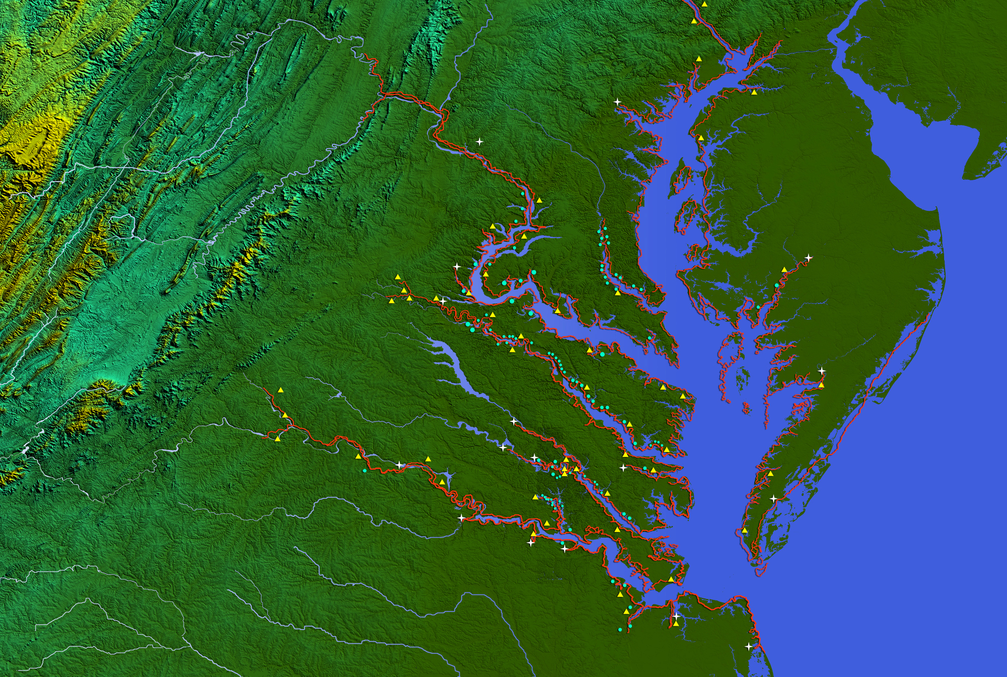
Fig. 4. Smith map overlaid on satellite map of Virginia with Indian towns in modern geographical coordinates.
Larger deviations are more telling. For example, it appears that Smith's knowledge of the northern portions of the bay were greater than the areas closer to Jamestown, where contact was more frequent and perhaps easier to accomplish. But even more interesting was Smith's positioning of Indian towns up and down the rivers of the bay. Indians located their towns on the fresh water rivers, away from the more saline and contaminated waters in the mouth of the bay. We now know the consequences of the English choice of the damp, swampy, mosquito-ridden Jamestown site: sickening and widespread death from water contamination. The map reveals Indian knowledge and English ignorance of the environment in the choices of where to locate a settlement. This knowledge was critically important to the success of the colony. Geographer Carville Earle, who first studied water quality in the Jamestown area, questioned whether the famous "starving winter" was really due entirely to the lack of food. Earle's work is confirmed by the graphic image of Indian settlements and their spatial organization around fresh water sources.
The effort to develop representations of the Algonquians subjected digital history to one of its more profound, if not unique challenges. First, we have only a handful of primary visual sources of the seventeenth-century world. Except for the great archive of images by John White of Algonquian-speaking Americans in the Outer Banks region of North Carolina in the 1580s, precious few images exist, almost none drawn on site in the New World. Second, just as in the case of text, for Indians, every image we have has been drawn by a European. Theoretically, explanatory models, whether colonial/post colonial, modern/postmodern or core/periphery operate on European conceptual turf, timetables, and agendas. Although contemporary writers have applied more refined and sensitive understandings to these theories, such as agency, or used new concepts, such as natives and strangers or "the middle ground," the emphasis remains on Europe. In one respect we faced the same obstacles as all previous historians of the colonial past have: in this case, how to overcome bias in the sources, deploy conceptual frameworks that take full account of the hegemonic designs of European imperialism without smothering the remarkable creativity and adaptability of native cultures or ignoring the contingencies of time, space, weather, climate, environment, and power that confronted adventurers and natives as they encountered the "other." Yet, visualization posed still another challenge—we were building our history in a medium where interpretive narrative was less compelling and where we could not substitute easily narrative for sources.
Despite these limitations, we can cull an immense body of work by archaeologists, ethnographers, linguists, climatologists, environmentalists, and others that, when combined with the textual and visual resources by historians, will allow graphics artists, working under the direction of knowledgeable historians, to recreate an Algonquian village of seventeenth-century Virginia. William Kelso, Chief Archaeologist, Jamestown Rediscovery (Association for the Preservation of Virginia Antiquities) and his team of specialists assembled an "archive" of material objects that radically expanded in the time I undertook the digital project. Archaeologists continue to excavate Indian sites and add to our knowledge of native peoples. New technologies may be applied to this evidence to recreate lost landscapes.
Why is visualization particularly useful as a technique for studying Chesapeake Indians? The absence of any text written by Indians or available texts about Indians written entirely from the perspective of colonizers makes it important to search for non-textual sources with which to supplement and validate the textual record. Site surveys of Indian villages and the material objects found in the excavations provide valuable evidence on non-literate populations. Visualizing an Indian village reveals objectifications of status and power, in the positioning and differential sizes of houses, or evidence of everyday life in the locations of cornfields and proximity of forest preserves and rivers.
The virtual village of Paspahegh is an example of our experiments to recapture visually one landscape of Algonquian life in Chesapeake Virginia. Archaeologists did a complete survey of the site and their findings have been preserved in the Virginia Department of Historic Resources. In the early phase of development for the Virtual Jamestown Web, Julie Solometo, an archaeologist and ethnographer, worked with the Virginia Center for Digital History to produce visual representations of the site from archaeological drawings and survey reports. John White's drawings of Algonquians at worship, work, and leisure provided realistic period images of seventeenth-century Algonquians. Site artifacts tell a story about trade relationships, diet and nutrition, housing, and everyday life. Eyewitness accounts in the Virtual Jamestown texts silo contain descriptions of encounters and the understandings and misunderstandings that surrounded them. The ultimate goal is an interactive, information-rich, visually-enhanced representation of a seventeenth-century Indian village in Chesapeake Virginia with hypertext links to first-hand accounts, John White's drawings, archaeological discoveries, oral histories of contemporary Indians, and roll-over deliveries of factual data. Patching together the pieces of Paspahegh life, work, and culture on a single landscape in time should stimulate analyses of village cultures, ceremonies, domestic relations, and other features of Chesapeake Algonquian society. All of this work is still in progress (see 3D Longhouse), but it has led to another design change.

Fig. 5. Mapping Paspahegh to the archaeological survey.
After years of experimentation with visualization technologies and substantial efforts at site redesign, Virtual Jamestown released a new site design in early 2008. "Resources" and "Envisionings" are the two major categories of content. Resources contain mostly the textual record (eyewitness accounts, court records, labor contracts, newspapers, and reference materials) for interpreting and understanding the history of the first permanent English settlement in America. Envisionings contain hypermedia representations (maps, images, artifacts, virtual reality renderings, and oral histories) of Jamestown. The categories are not without ambiguity and this is not likely to be the "final" design for the site. As additional resources are brought online or new technologies or software tools are applied to traditional sources, new site designs will be necessary to improve transparency and reduce ambiguity.

Fig. 6. Present Site Design.
As other digital historians have noted, presentation may be the area where new technologies have the greatest potential for the practice of history. Virtual Jamestown allows one to experience the act of being a historian: read the moving words of Powhatan's oration, see Algonquians fishing, listen to contemporary Indian descendants reflect upon Jamestown's meaning, study the laws and statutes of the Virginia General Assembly, examine the appearance, clothing, and bundles of runaway slaves and indentured servants, trace the voyages of John Smith up and down the rivers of the Chesapeake Bay, listen to John Rolfe explain why he wanted to marry an Indian girl, and much more. What we take for granted now was not possible even fifteen years ago: incorporating multiple voices, diverse audiences, and popular participation in the unlocking, presentation, and preservation of a distant past. We might even be able to represent a new colonial history of encounter.
1 Sherry Turkel, Life on the Screen: Identity in the Age of the Internet (New York, London, Toronto, Sydney, Tokyo, Singapore: Simon & Schuster, 1995).
2 Ben Shneiderman, Designing the User Interface: Strategies for Effective Human-Computer Interaction. Third Edition (Reading, Mass.; Harlow, England; Menlo Park, Calif.; Don Mills, Ontario; Sydney; Bonn; Amsterdam; Tokyo; Mexico City: Addison-Wesley, 1998).
3 Crandall Shifflett, "Seeing the Past: Digital History as New Model Scholarship," Merlot Journal of Online Learning and Teaching, Vol. 3, No. 1, (March 2007): 58-66. See also David J. Staley, Computers, Visualization and History (Armonk, New York and London, England: M. E. Sharpe, 2003); William G. Thomas, III, "Is the Future of Digital History Spatial History," Newberry Library Historical GIS Conference, March 2004.